Proxectos

Going to the northernmost corner of the province of A Coruña, the Ferrolterra and Ortegal regions both safeguard and showcase a truly unique piece of Galicia’s geological heritage, one that is now a candidate to receive the prestigious distinction of a UNESCO Geopark.

Backed by numerous studies carried out by the Spanish Geological Society and recognised by the international scientific community, the Cape Ortegal complex is a worldwide geological benchmark. With this in mind, the Cape Ortegal Geopark project was created as a collaborative initiative between A Coruña’s Provincial Government and the city councils of Cariño, Cedeira, Cerdido, Moeche, San Sadurniño, Ortigueira and Valdoviño.

What would it mean to be designated as a Geopark by UNESCO?

The Global Geopark designation is a recognition granted by UNESCO aimed at preserving and disseminating information about geographical areas with a unique geological heritage and a great ethnographic, ecological and cultural richness associated with these “geosites”. Their goal is for this “badge of quality” to serve as a tool to spread information and educate and unite the local community with regards to scientific value of the region, offer and position a top-notch touristic experience and, finally, guarantee the sustainable return of its profits, or, in other words, to conserve both the geological heritage and touristic development.

Currently, there are 147 Geoparks located in 41 different countries. Spain has been awarded 13 of these prestigious designations, positioning it second in the worldwide ranking behind China.

Why Cape Ortegal?

With around 630 square kilometres, this project is lead by A Coruña’s Provincial Government and built around one of the most complete allochthonous arrays of the European Variscan orogeny which contains a wide range of formations such as folds, faults and thrust faults created during the Palaeozoic continental collision between the Laurussia and Gondwana supercontinents.

Commonly, this region, from the Capelada Mountains to where the Atlantic Ocean and the Cantabrian Sea meet at Cape Ortegal, is generally known to be home to continental Europe’s highest sea cliffs. Despite this truism, the real added value of this topography is that it was formed 350 million years ago when some of the materials it is made of were still resting at depths of 70 kilometres along the ocean crust and in the Earth’s mantle.

However, the exceptional scientific nature of the Cape Ortegal complex is not limited to the coast, but also extends inland. San Sadurniño, Moeche and Cerdido are areas with a strong mining tradition centred on the pyrite mines in Piuito and Barueira thanks to their numerous serpentinite quarries (a type of green marble).

For all these reasons, and many more, it is often said that “visiting this iconic geological landscape is like taking a journey inside the Earth”.

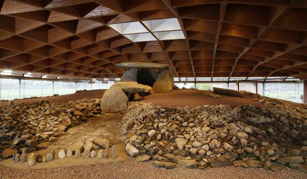
The Costa da Morte (Coast of Death) evokes the Neolithic culture with its more than 300 tumuli, dolmens and other funeral structures, one of the best preserved and most representative areas of the new Stone Age in Galicia.

Megalithism in this region occurred between approximately the 4th and 3rd centuries B.C., part of a larger movement found all throughout Western Europe. The most prevalent and characteristic type of these monuments are the tumuli and dolmens. The former, also called mámoas, are circular or oval-shaped structures comprised of large stones and a layer of earth, used as sepulchres or boundary markers. The latter, also used as tombs, are comprised of various vertical slabs of stone and a horizontal capstone emerging from the earth.

Why are they so important?

The reason why the Costa da Morte’s megalithic structures are noteworthy is due to their archaeoastronomical connotations. It was the position of the moon, the sun and other stars that determined exactly how these monuments were built, without following a common pattern regarding their positioning. Some face the location where the sun rises on the winter solstice while others are aligned with the position of the southern minor lunar standstill. Some even face specific stars.

A few of the more important monumental tombs or dolmens are Pedra Moura, Pedra Cuberta, Pedra da Arca, Fornela dos Mouros and the Dombate Dolmen, also known as the “Cathedral of Megalithism”.

Strategic Goals

With all this in mind, a new strategy was conceived that is aimed at preserving and making people aware of this history, creating a spectacular network of “outdoor museums”. This project, named the Megalithic Archaeological Park, is a joint initiative carried out by the city councils of Laracha, Cabana de Bergantiños, Carballo, Dumbría, Laxe, Malpica de Bergantiños, Mazaricos, Ponteceso, Vimianzo and Zas and A Coruña’s Provincial Government.

From the terms petros (stone) and glyphein (carve), petroglyphs are defined as graphic representations carved into rocks or stones. It was a grouping of these outdoor rock carvings, with their complex symbologies, that were the first traces of writing.

In Galicia, the majority of these carvings date to the Metal Age, more specifically to the Bronze Age when copper was first melted with tin.

Geography and Context

In the Ulla and Maía Valley regions, found within the municipalities of Ames, Brión, Santiago, Teo and Val do Dubra, around 120 petroglyphs have been catalogued which depict a wide range of figures that include everything from animals and weapons to labyrinths and crosses.

In 2016, a fire scorched the San Miguel Mountain, revealing many of these carvings that had previously been hidden under the area’s vegetation. Despite this fortuitous discovery, the event adversely affected the optimal preservation of these petroglyphs in addition to seriously damaging the surrounding natural environment.

The Project

Due to this, and its ethnographic importance, a collaborative initiative was created between various municipalities in order to implement a research, preservation and dissemination project for the rock art found in this region called the “Compostela Rock Art Park”.